


F26310_col_de_Cabres_Luzet_Beaurières_LT_LCV_N3

ageo
User
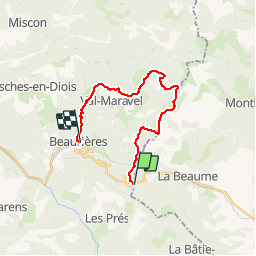

Length
19.5 km

Max alt
1685 m

Uphill gradient
986 m
Km-Effort
34 km

Min alt
743 m

Downhill gradient
1414 m
Boucle
No
Creation date :
2017-07-08 00:00:00.0
Updated on :
2017-07-08 00:00:00.0
6h30
Difficulty : Medium

FREE GPS app for hiking
 SityTrail
IGN / Geographical institutes
SityTrail Plus
The world is yours!
About
Trail Walking of 19.5 km to be discovered at Provence-Alpes-Côte d'Azur, Hautes-Alpes, La Beaume. This trail is proposed by ageo.


Positioning
Country:
France
Region :
Provence-Alpes-Côte d'Azur
Department/Province :
Hautes-Alpes
Municipality :
La Beaume
Location:
Unknown
Start:(Dec)
Start:(UTM)
706406 ; 4936196 (31T) N.
Comments